
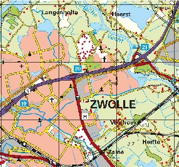
Topografische kaart 1:100000
De nieuwe TOP100 raster is gemaakt door middel van automatische generalisatie uit TOP10NL. Het Kadaster heeft gekozen voor een detailniveau dat uitstekend geschikt is voor kleinschalige toepassingen. TOP100 raster is geschikt als topografische ondergrond in GIS, CAD en Desktop Mapping.
Standard
dataIdentificatie
- Title
-
Topografische kaart 1:100000
- Date (Creation)
- 2019-06-01
- Date (Publication)
- 2024-07-09
- Date (Revision)
- 2024-06-20
- Unique resource identifier
-
5539ebdf-4c65-413f-ad70-61b64dc0c63b
- Status
- On going
- Metadata language
- Nederlands; Vlaams
-
Interprovinciale thesaurus
-
-
topografische kaarten
-
Constraints
- Use limitation
-
Geen gebruiksbeperkingen
- Use limitation
-
Geoportaal extern
- Use limitation
-
Downloadable data
Legal constraints
- Access constraints
- Copyright
- Other constraints
- Other constraints
-
Geen beperkingen
- Classification
- Restricted
- Point of contact
-
individualName organisationName electronicMailAddress role klantcontactcenter
Kadaster
Owner
spatialInfo
))
- Distance
- 5 meters
- Distance
- 5 meters
- referenceSystemIdentifier
-
https://www.opengis.net/def/crs/EPSG/0/https://www.opengis.net/def/crs/EPSG/0/28992
DataQuality
- Hierarchy level
- Dataset
- Lineage
-
TOP100raster is automatisch gegeneraliseerd uit TOP10NL.
Metadata
- Metadata language
- Nederlands; Vlaams
- Hierarchy level
- Dataset
- Metadata author
-
individualName organisationName electronicMailAddress role team Data, Informatie, GIS en Innovatie
Provincie Overijssel
Custodian
Overviews
)))
Provided by
