
Stiltegebieden (Omgevingsvisie)
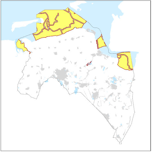
Dit bestand bevat stiltegebieden zoals opgenomen in de Omgevingsvisie van de provincie Groningen. In de dunbevolkte provincie Groningen is stilte een van de kernkarakteristieken (zie 5.3). Daarom beschermt de provincie de stilte en verbetert deze waar het kan. De provincie kent drie stiltegebieden (delen van) het Waddengebied, de oevers van het Schildmeer en het Lauwersmeergebied.
Standard
dataIdentificatie
- Title
-
Stiltegebieden (Omgevingsvisie)
- Date (Publication)
- 2026-06-06
- Unique resource identifier
-
a9de407b-f30e-4f29-b490-187beef90812
- Status
- Completed
- Metadata language
- Nederlands; Vlaams
-
Interprovinciale thesaurus
-
-
STILTEGEBIEDEN
-
RUIMTELIJKE KWALITEIT
-
GELUIDHINDER
-
NATUURGEBIEDEN
-
RUIMTELIJKE ORDENING
-
Omgevingsvisie
-
OMGEVINGSWET
-
BELEIDSPLANNEN (VORM)
-
Ambitie
-
- Use limitation
-
Geen gebruiksbeperkingen.
Legal constraints
- Access constraints
- Other restrictions
- Other constraints
- Geen beperkingen
- Point of contact
-
Individual name Organisation name Electronic mail address Role Team Milieu
Provincie Groningen
Owner
spatialInfo
))
- Denominator
- 50000
- referenceSystemIdentifier
DataQuality
- Hierarchy level
- Dataset
- Lineage
-
provincie Groningen
Metadata
- Metadata language
- Nederlands; Vlaams
- Hierarchy level
- Dataset
- Metadata author
-
Individual name Organisation name Electronic mail address Role Datateam Beleid
Provincie Groningen
Point of contact
)))