
Rotterdam 3D
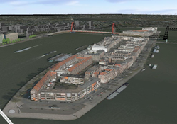
De panden in Rotterdam zijn op basis van de BAG en Laseraltimetrie gemodelleerd inclusief texturen op basis van een luchtfoto
Simple
Basis
- Title
-
Rotterdam 3D
- Unique resource identifier
-
7D752836-1117-42A9-96D1-D7D168458A01
- Status
- On going
-
-
3D, Rotterdam, Citygml
-
- Date (Creation)
- 2009-01-01
- Statement
-
BAG, Lidar, luchtfoto
- Point of contact
-
organisationName electronicMailAddress role Gemeente Rotterdam
Point of contact
- Use limitation
-
geen beperkingen
Legal constraints
- Access constraints
- Other restrictions
- Use constraints
- Other restrictions
- Other constraints
-
geen beperkingen
- Other constraints
spatial
N
S
E
W
))
- Denominator
- 5000
Metadata
- Metadata author
-
organisationName electronicMailAddress role Gemeente Rotterdam
Point of contact
)))
